On October 6, 2025, William C. Wonders Map Collection staff uploaded our 3000th map to Internet Archive (IA). The 1912 plan showing survey of Old Trail being part of Old Trail from Saddle Lake to Lac la Biche, in classic ozalid, and a 20 footer1 covering a distance over 100 kilometers. It has now become the longest map we have scanned.2
Since 2021 the collection of maps on IA has been growing. Relying on intermittent Digitization staff and student hours, SLIS and MacEwan practicums, and the initial core work of the Metadata Strategies team in creating a spreadsheet that aligns the map collection database3 with IA metadata structures. To all these individuals we owe a great deal of gratitude!
Many of the maps uploaded are a result of reference questions from across North America4 with IA providing fast turnarounds for sharing maps. Allowing researchers, and the general public, to quickly download the scanned images.
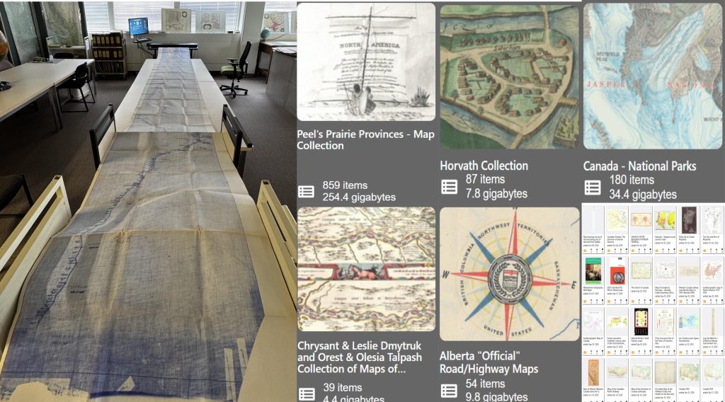
Figure 1. Shows the scanning of the plan showing survey of Old Trail being part of Old Trail from Saddle Lake to Lac la Biche alongside the nested-collections mentioned below and includes a screen capture of recently added maps.
There are also many fascinating nested-collections including Peel’s Prairie Provinces – Map Collection which was harvested from its original server location, hosted by the University of Alberta Library. The Horvath Collection of maps that are part of the J. Eugene Horvath Collection of Hungarica.5 If you enjoy historical Alberta Highway Maps, the collection goes back to the 1920s.6 The vibrant Chrysant & Leslie Dmytruk and Orest & Olesia Talpash Collection of Ukraine & Eastern Europe maps that were donated to Bruce Peel Special Collections have also been added. As these unique maps were processed for IA, map staff researched each individual map item to enhance their descriptions.7
There is a collection of Canada’s National Parks maps that have an associated Indigenous Peoples & Canada’s National Parks LibGuide. This project is part of ongoing work to decolonize the William C. Wonders Map Collection. In this case, through awareness that the Indigenous peoples experience and the creation of Canada’s National Park system was/is a continuation of settler colonialism.
Curious about our most viewed IA map? Interestingly it is Karta vashneishikh mestorozhdenii polynikh iskopaemikh Aziatskoi Rossii a 1924 map of important mineral deposits in the Asian-Russian region.
We encourage you to share the collection within your networks, update your LibGuides, and contact us at data@ualberta.ca with any questions and/or suggestions for maps you would like to see added to the William C. Wonders Map Collection on Internet Archive. If you are on Bluesky we post when new maps are added to IA, along with other cartographic and GIS news.
- Quint swears it’s twenty-five. ↩︎
- Log Salt Well No. I. Drilled in 1947 by the Alberta Government in Fort McMurray – is a close 2nd. ↩︎
- The William C. Wonders Map Collection Database is an electronic index to the pre-1995 maps. Begun as an electronic version of the catalogue records in 26 historical handwritten binders. ↩︎
- The Graphic map of Africa is an example of reference work. In this case a faculty member from the University of Winnipeg was looking for a map showing the dates and agreements related to Africa’s colonial boundaries in the late 1800s. We first identified the map in the physical collection. Then scanned and shared via IA within two hours. ↩︎
- These maps are part of the J. Eugene Horvath collection of Hungarica. A collection of books and maps on Central/Eastern Europe and Hungary. Additional descriptions are available in J. Eugene Horvath’s: A Canadian collection of Hungarica, Volume II, Maps and City Views 1493-1817, published 2001. ↩︎
- Watch the development of The David Thompson Highway from Rocky Mountain House through Nordegg. Including the planned Adventure Road to Saskatchewan River Crossing. 1934, 1946, 1962. ↩︎
- Ukrania quae et terra Cosaccorvm cum vicinis Walachiae, Moldaviae, Minorisquae, Tartariae provinciis. exhibita a Ioh Baptista Homanno Noriberae. Cum privilegio Sac. Caes Majesti. A map covering Ukraine, Wallachia, Transylvania, Romania, Belarus, Hungary, Poland and Russia provides an example of enhanced IA description fields that were created by Bonnie Gallinger. ↩︎