Submission 2025
| Submitted by: | Rohini Chatterjee |
| Department: | Earth + Atmospheric Sciences |
| Faculty: | Science |
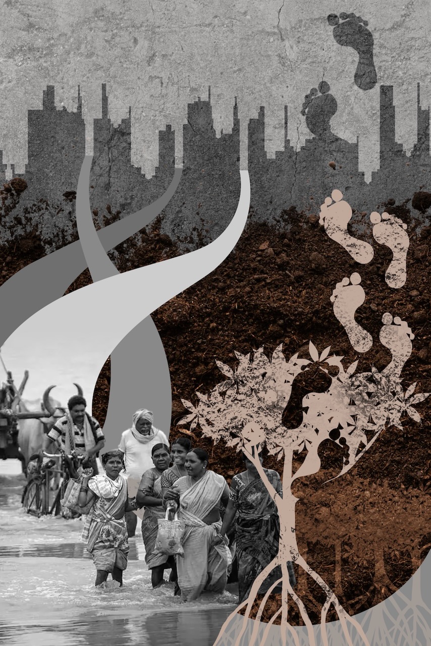
This illustration captures the entangled realities of climate change and displacement in the Sundarbans—a fragile deltaic region in West Bengal (India), home to the world’s largest mangroves! It juxtaposes rising urban silhouettes with rural life wading through floodwaters, symbolizing the journey from rooted traditions to uncertain urban futures. As sea levels rise and cyclonic events increase in these coastal regions, both human and ecological systems face existential threats. The footsteps—etched in soil and leaves—represent the irreversible imprint of migration and loss. Each compositional choice was guided by a key insight: that migration is not just a reaction to climate—it is a spatial and emotional transition shaped by inequality, policy gaps, and urban design failures.
My research investigates how climate shocks, environmental vulnerability, and socio-political stressors converge to displace the marginalized communities (e.g., women, children, and ecological guardians— mangroves that bear the brunt of climate disruptions). It further explores how these forced migrations reshape urban settlements, challenging the resilience, inclusivity, and preparedness of Indian cities.
Was your image created using Generative AI?
No.
How was your image created?
This image was developed by me in Adobe Photoshop as a conceptual visualization of my doctoral research in climate-induced migration from the Sundarbans region. The design process began by sourcing high-resolution satellite imagery and photographs of key environmental elements: mangrove forests, flooded rural settlements, storm clouds, and urban skylines. These were imported as separate layers into Photoshop for compositing. I used a multi-layered workflow to blend disparate landscapes using Layer Mask tool to create smooth transitions between terrain features—submerging the rural ground into rising water and fading mangrove textures into looming city structures. I further used Adjustment Layers (Curves, Hue/Saturation, and Selective Color) to establish a moody, high-contrast color palette representing environmental tension. Footprint vectors were added and manually warped using the Transform > Warp tool to simulate depth and topographical contour. I finished the illustration with cloud and wave elements with varying opacities and Gaussian Blur effects to evoke motion and instability. The final composition was flattened and exported in CMYK format for high-resolution print.
Where is the image located?
This poster was conceptualized and designed using Adobe Photoshop, combining different medium of digital layering to symbolically represent climate-induced migration and urban transformation.